Tungurahua
| Tungurahua | |
|---|---|
| Elevation | 5,023 m |
| Latitude | 1° 28′ 1″ S |
| Longitude | 78° 26′ 30″ W |
Tungurahua is an active volcano in Ecuador.
Eruptions
16 December 2012

On 16 December the ash plume, generated by a large explosion, rose to a maximum height of 7 km and contained lightning. [1] Other explosions generated ash plumes up to 2 km high. Satellite imagery showed ash plumes drifting 140 km NW, and 110 km NE at an altitude of 7.9 km a.s.l. The larger explosions during the morning were followed by pyroclastic flows that descended the SW and NW flanks. [2] The Washington VAAC issued a volcanic ash alert at 13:00 UTC. [3]
On 17 December satellite images showed ash plumes drifting 50-130 km NE, and a dense ash plume drifting over 200 km NE at an altitude of 7 km a.s.l. IG noted that explosions continued to generate ash plumes, but with progressively decreasing ash content. Ash plumes drifted NNE and NE, causing ashfall in communities downwind.[4]
On 17 Dec. people living on the slopes of the Tungurahua volcano were evacuated.[5] [6]
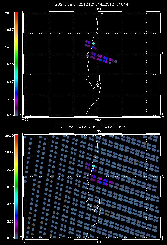
Here a fast look at IASI data, with ours SO2 detection flag (= a fast linear retrieval with a lot of assumptions, like the standard atmospheric profiles etc...) [7] [8]. More quantitative data (a proper retrieval) will follow.
References
- ↑ Smithsonian/USGS Volcanic Activity Report http://www.volcano.si.edu/reports/usgs/
- ↑ http://www.volcano.si.edu/world/volcano.cfm?vnum=1502-08=&volpage=weekly
- ↑ Washington Volcanic Ash Advisory Center (VAAC) http://www.ssd.noaa.gov/VAAC/messages.html
- ↑ Instituto Geofísico-Escuela Politécnica Nacional (IG) http://www.igepn.edu.ec/
- ↑ ABC News http://abcnews.go.com/International/wireStory/ecuadors-tungurahua-volcano-prompts-evacuations-17999286#.UNM8ctHCaHc
- ↑ BBC News http://www.bbc.co.uk/news/world-latin-america-20765920
- ↑ Walker, J.C., E. Carboni, A. Dudhia, R.G. Grainger: Improved Detection of Sulphur Dioxide in Volcanic Plumes using Satellite-based Hyperspectral Infra-red Measurements: Application to the Eyjafjallaj?okull 2010 Eruption, J. Geophys. Res., 117, doi:10.1029/2011JD016810, 2012.
- ↑ Walker, J. C., Dudhia, A., & Carboni, E. (2011). An effective method for the detection of trace species demonstrated using the MetOp Infrared Atmospheric Sounding Interferometer. ATMOS MEAS TECH, 4(8), 1567-1580. doi:10.5194/amt-4-1567-2011
